


VTT(74) - N°7 - Tour de la Vallée Verte - 32 km - 966m+ - 2h50

HG74250
User
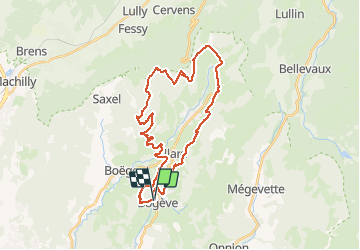

Length
32 km

Max alt
1302 m

Uphill gradient
966 m
Km-Effort
45 km

Min alt
767 m

Downhill gradient
969 m
Boucle
Yes
Creation date :
2021-04-24 07:24:59.799
Updated on :
2021-04-25 08:06:00.806
3h17
Difficulty : Difficult

FREE GPS app for hiking
 SityTrail
IGN / Geographical institutes
SityTrail Plus
The world is yours!
About
Trail Mountain bike of 32 km to be discovered at Auvergne-Rhône-Alpes, Upper Savoy, Bogève. This trail is proposed by HG74250.
Description
Crêtes de Burdignin et Retour par le Col du Perret surla gauche de Villard.
Positioning
Country:
France
Region :
Auvergne-Rhône-Alpes
Department/Province :
Upper Savoy
Municipality :
Bogève
Location:
Unknown
Start:(Dec)
Start:(UTM)
301584 ; 5118868 (32T) N.
Comments