


2021-04-25_20h45m15_SityTrail - 2751134 - Montardon-

mitch1952
User
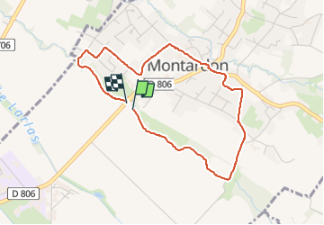

Length
4.1 km

Max alt
214 m

Uphill gradient
23 m
Km-Effort
4.4 km

Min alt
200 m

Downhill gradient
22 m
Boucle
Yes
Creation date :
2021-04-25 18:45:16.085
Updated on :
2022-06-08 13:23:01.672
59m
Difficulty : Easy

FREE GPS app for hiking
 SityTrail
IGN / Geographical institutes
SityTrail Plus
The world is yours!
About
Trail On foot of 4.1 km to be discovered at New Aquitaine, Pyrénées-Atlantiques, Montardon. This trail is proposed by mitch1952.
Positioning
Country:
France
Region :
New Aquitaine
Department/Province :
Pyrénées-Atlantiques
Municipality :
Montardon
Location:
Unknown
Start:(Dec)
Start:(UTM)
714269 ; 4804769 (30T) N.
Comments