Trail Nordic walking Moyenvic - plaine et forêt - Photo

plaine et forêt

 Ajul
Ajul

User

© OpenStreetMap contributors
Length
Length
19.7 km
Max alt
Max alt
340 m
Uphill gradient
Uphill gradient
406 m
Km-Effort
Km-Effort  
25 km
Min alt
Min alt
196 m
Downhill gradient
Downhill gradient
404 m
Boucle
Boucle
Yes
Creation date :
2021-04-29 15:46:39.121
Updated on :
2021-04-29 15:58:51.296

(0 Reviews)

Nordic walking
Nordic walking
--
Difficulty : Medium

Scan this QR Code to open this trail in the SityTrail application

FREE GPS app for hiking

Logo SityTrail SityTrail

IGN / Geographical institutes

Download SityTrail from the App Store Download SityTrail from Google Play

Logo SityTrail SityTrail World

The world is yours!

Download SityTrail from the App Store Download SityTrail from Google Play Download SityTrail on Huawei AppGallery

About

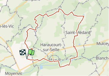
Trail Nordic walking of 19.7 km to be discovered at Grand Est, Moselle, Moyenvic. This trail is proposed by Ajul.

Description

20 km et 400m de dénivelé. belle rando dans la Nature variée du Saulnois. Départ de l'abri de Moyenvic sur GR5, Marsal, St Médard, table de pique nique à 9km du départ, parcours en forêt, chapelle St Livier, chemin de la côte St Jean, table d'orientation, retour à l'abri.(avec chaussure de marche)

Elevation profile

Positioning

Country:
France
Region :
Grand Est
Department/Province :
Moselle
Municipality :
Moyenvic
Location:
Unknown
Start:(UTM)
322096 ; 5406981 (32U) N.

Trails nearby

Trail Walking Moyenvic - les hauts de Sain-Jean - Photo
Walking
viverols

Walking

Very easy
(1)
Moyenvic, Grand Est, Moselle, France
7.2 km | 9.1 km-effort
2h 0min
Yes
Trail Walking Saint-Médard - marche de Saint Medard - Photo
Walking
didier cornelius

Walking

Easy
Saint-Médard, Grand Est, Moselle, France
10.9 km | 13.2 km-effort
3h 53min
Yes
Trail Cycle Château-Salins - Le Pays du Saulnois,  l'histoire du sel. (Circuit 17) - Photo
Cycle
tracegps

Cycle

Difficult
(1)
Château-Salins, Grand Est, Moselle, France
52 km | 62 km-effort
3h 0min
Yes
Trail Walking Vic-sur-Seille - Bezange la Grande - Photo
Walking
didier cornelius

Walking

Easy
Vic-sur-Seille, Grand Est, Moselle, France
11 km | 13.4 km-effort
2h 10min
Yes
Trail Walking Moyenvic - sortie 4 5 - Photo
Walking
bellophilippe

Walking

Difficult
Moyenvic, Grand Est, Moselle, France
11.2 km | 12.5 km-effort
1h 57min
Yes
Trail Walking Moyenvic - boucle départ moyenvic  - Photo
Walking
bellophilippe

Walking

Very difficult
Moyenvic, Grand Est, Moselle, France
27 km | 33 km-effort
5h 22min
Yes
Trail Walking Vic-sur-Seille - vic moyenvic par stade - Photo
Walking
bellophilippe

Walking

Easy
Vic-sur-Seille, Grand Est, Moselle, France
4.2 km | 4.8 km-effort
54min
No
Trail Walking Moyenvic - Moyenvic vic boucle  - Photo
Walking
bellophilippe

Walking

Medium
Moyenvic, Grand Est, Moselle, France
14.8 km | 18.5 km-effort
3h 24min
Yes
Trail Walking Moyenvic - sortie du 20923 - Photo
Walking
bellophilippe

Walking

Medium
Moyenvic, Grand Est, Moselle, France
14.7 km | 17 km-effort
3h 24min
Yes


Close
My subscriptions