Trail Walking Morville-sur-Seille - Morville-sur-Seille, Eply, Raucourt 15 650m +153m - Photo

Morville-sur-Seille, Eply, Raucourt 15 650m +153m

© OpenStreetMap contributors
Length
Length
15.6 km
Max alt
Max alt
242 m
Uphill gradient
Uphill gradient
153 m
Km-Effort
Km-Effort  
17.7 km
Min alt
Min alt
174 m
Downhill gradient
Downhill gradient
153 m
Boucle
Boucle
Yes
Creation date :
2021-05-07 07:30:07.728
Updated on :
2021-05-08 07:42:37.279

(0 Reviews)

Walking
Walking
4h30
Difficulty : Difficult

Scan this QR Code to open this trail in the SityTrail application

FREE GPS app for hiking

Logo SityTrail SityTrail

IGN / Geographical institutes

Download SityTrail from the App Store Download SityTrail from Google Play

Logo SityTrail SityTrail World

The world is yours!

Download SityTrail from the App Store Download SityTrail from Google Play Download SityTrail on Huawei AppGallery

About

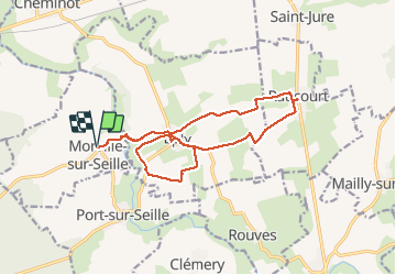
Trail Walking of 15.6 km to be discovered at Grand Est, Meurthe-et-Moselle, Morville-sur-Seille. This trail is proposed by DanielROLLET.

Description

2021 05 07 Reco balisage pour Rando 54 avec Marie.
Beau temps mais venteux et frais.
9h30 à 14h00

Elevation profile

Positioning

Country:
France
Region :
Grand Est
Department/Province :
Meurthe-et-Moselle
Municipality :
Morville-sur-Seille
Location:
Unknown
Start:(UTM)
291638 ; 5422145 (32U) N.

Trails nearby

Trail Walking Belleau - Manoncourt sur seille  - Photo
Walking
jean-marie.parachini

Walking

Easy
Belleau, Grand Est, Meurthe-et-Moselle, France
9.5 km | 11.1 km-effort
4h 3min
Yes
Trail Walking Lesménils - Lesmenils - Le Xon - Photo
Walking
jean-marie.parachini

Walking

Easy
Lesménils, Grand Est, Meurthe-et-Moselle, France
5 km | 6.9 km-effort
2h 10min
Yes
Trail Walking Éply - SC3 Circuit les Prés Bas 4 500m + 39m - Photo
Walking
DanielROLLET

Walking

Easy
Éply, Grand Est, Meurthe-et-Moselle, France
4.7 km | 5.3 km-effort
1h 3min
Yes
Trail Walking Bouxières-sous-Froidmont - Bouxières sous Froidmont - Photo
Walking
joelclaudel

Walking

Difficult
Bouxières-sous-Froidmont, Grand Est, Meurthe-et-Moselle, France
19.3 km | 26 km-effort
5h 26min
Yes
Trail Hybrid bike Cheminot - Sort avec lola - Photo
Hybrid bike
meon

Hybrid bike

Easy
Cheminot, Grand Est, Moselle, France
8.6 km | 9.3 km-effort
49min
Yes
Trail Mountain bike Cheminot - Autour de Cheminot  - Photo
Mountain bike
meon

Mountain bike

Very difficult
Cheminot, Grand Est, Moselle, France
44 km | 52 km-effort
3h 29min
No
Trail Walking Lesménils - Xon - Lesmenils  - Photo
Walking
JeanPierreNancy

Walking

Medium
Lesménils, Grand Est, Meurthe-et-Moselle, France
11.7 km | 15.9 km-effort
3h 36min
Yes
Trail Walking Lesménils - 9183123-Xon et forêt de Facq - Photo
Walking
jean-marie.parachini

Walking

Difficult
(1)
Lesménils, Grand Est, Meurthe-et-Moselle, France
10.3 km | 13.2 km-effort
3h 0min
Yes
Trail Walking Éply - des anciens bois - Photo
Walking
DanielROLLET

Walking

Medium
Éply, Grand Est, Meurthe-et-Moselle, France
7.1 km | 8 km-effort
1h 48min
Yes


Close
My subscriptions