


Col d’Ibardin - Chapelle d’Olhette descente

Loic3
User
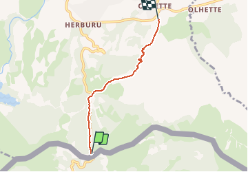

Length
4 km

Max alt
318 m

Uphill gradient
43 m
Km-Effort
5.4 km

Min alt
45 m

Downhill gradient
307 m
Boucle
No
Creation date :
2021-05-07 14:19:44.0
Updated on :
2021-05-07 15:17:09.959
57m
Difficulty : Unknown

FREE GPS app for hiking
 SityTrail
IGN / Geographical institutes
SityTrail Plus
The world is yours!
About
Trail Walking of 4 km to be discovered at New Aquitaine, Pyrénées-Atlantiques, Urrugne. This trail is proposed by Loic3.
Positioning
Country:
France
Region :
New Aquitaine
Department/Province :
Pyrénées-Atlantiques
Municipality :
Urrugne
Location:
Unknown
Start:(Dec)
Start:(UTM)
606681 ; 4796109 (30T) N.
Comments