


Boucle du lac de St Leger BF LE 8 MAI

claude nier
User
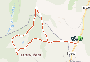

Length
5.5 km

Max alt
1405 m

Uphill gradient
211 m
Km-Effort
8.4 km

Min alt
1308 m

Downhill gradient
211 m
Boucle
Yes
Creation date :
2021-05-08 08:00:34.582
Updated on :
2021-05-08 08:02:16.523
1h54
Difficulty : Easy

FREE GPS app for hiking
 SityTrail
IGN / Geographical institutes
SityTrail Plus
The world is yours!
About
Trail On foot of 5.5 km to be discovered at Provence-Alpes-Côte d'Azur, Alpes-de-Haute-Provence, Ubaye-Serre-Ponçon. This trail is proposed by claude nier.
Description
CREATION
Positioning
Country:
France
Region :
Provence-Alpes-Côte d'Azur
Department/Province :
Alpes-de-Haute-Provence
Municipality :
Ubaye-Serre-Ponçon
Location:
Unknown
Start:(Dec)
Start:(UTM)
289325 ; 4921887 (32T) N.
Comments