


BOUCLE DU LAC ST LEGER BF LE 8 MAI

claude nier
User
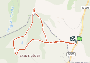

Length
5.3 km

Max alt
1405 m

Uphill gradient
184 m
Km-Effort
7.7 km

Min alt
1303 m

Downhill gradient
184 m
Boucle
Yes
Creation date :
2021-05-08 08:11:24.915
Updated on :
2021-05-08 08:11:59.409
1h45
Difficulty : Easy

FREE GPS app for hiking
 SityTrail
IGN / Geographical institutes
SityTrail Plus
The world is yours!
About
Trail On foot of 5.3 km to be discovered at Provence-Alpes-Côte d'Azur, Alpes-de-Haute-Provence, Ubaye-Serre-Ponçon. This trail is proposed by claude nier.
Positioning
Country:
France
Region :
Provence-Alpes-Côte d'Azur
Department/Province :
Alpes-de-Haute-Provence
Municipality :
Ubaye-Serre-Ponçon
Location:
Unknown
Start:(Dec)
Start:(UTM)
289328 ; 4921887 (32T) N.
Comments