


Dolus d'Oleron

Claudinette17
User
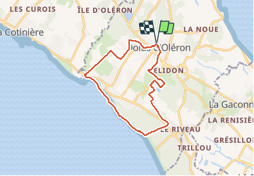

Length
13.5 km

Max alt
17 m

Uphill gradient
75 m
Km-Effort
14.5 km

Min alt
-1 m

Downhill gradient
75 m
Boucle
Yes
Creation date :
2021-05-09 06:52:06.437
Updated on :
2021-05-09 10:17:42.078
3h24
Difficulty : Difficult

FREE GPS app for hiking
 SityTrail
IGN / Geographical institutes
SityTrail Plus
The world is yours!
About
Trail Walking of 13.5 km to be discovered at New Aquitaine, Charente-Maritime, Dolus-d'Oléron. This trail is proposed by Claudinette17.
Positioning
Country:
France
Region :
New Aquitaine
Department/Province :
Charente-Maritime
Municipality :
Dolus-d'Oléron
Location:
Unknown
Start:(Dec)
Start:(UTM)
634737 ; 5085783 (30T) N.
Comments