


ST ALEXIS HERRLISHEIM

jcschubnel
User
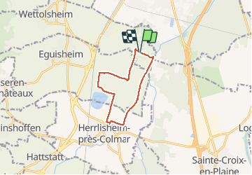

Length
9.1 km

Max alt
199 m

Uphill gradient
36 m
Km-Effort
9.6 km

Min alt
186 m

Downhill gradient
35 m
Boucle
Yes
Creation date :
2021-04-27 12:20:35.39
Updated on :
2021-05-10 15:38:30.801
2h17
Difficulty : Very easy

FREE GPS app for hiking
 SityTrail
IGN / Geographical institutes
SityTrail Plus
The world is yours!
About
Trail Walking of 9.1 km to be discovered at Grand Est, Haut-Rhin, Wettolsheim. This trail is proposed by jcschubnel.
Positioning
Country:
France
Region :
Grand Est
Department/Province :
Haut-Rhin
Municipality :
Wettolsheim
Location:
Unknown
Start:(Dec)
Start:(UTM)
376789 ; 5322662 (32U) N.
Comments