


ITILAR066V51NAY7

jeromelacoste
User
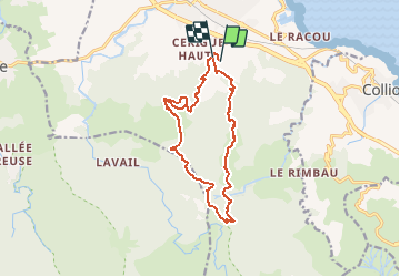

Length
15.6 km

Max alt
775 m

Uphill gradient
853 m
Km-Effort
27 km

Min alt
46 m

Downhill gradient
865 m
Boucle
No
Creation date :
2021-05-10 16:36:39.931
Updated on :
2021-05-10 16:43:39.515
5h00
Difficulty : Very difficult

FREE GPS app for hiking
 SityTrail
IGN / Geographical institutes
SityTrail Plus
The world is yours!
About
Trail Walking of 15.6 km to be discovered at Occitania, Pyrénées-Orientales, Argelès-sur-Mer. This trail is proposed by jeromelacoste.
Photos

Positioning
Country:
France
Region :
Occitania
Department/Province :
Pyrénées-Orientales
Municipality :
Argelès-sur-Mer
Location:
Unknown
Start:(Dec)
Start:(UTM)
502447 ; 4708755 (31T) N.
Comments