


13.05.21

jmkrust
User

Length
7.2 km

Max alt
260 m

Uphill gradient
45 m
Km-Effort
7.8 km

Min alt
243 m

Downhill gradient
45 m
Boucle
Yes
Creation date :
2021-05-13 07:51:45.282
Updated on :
2021-05-13 08:29:26.222
37m
Difficulty : Easy

FREE GPS app for hiking
 SityTrail
IGN / Geographical institutes
SityTrail Plus
The world is yours!
About
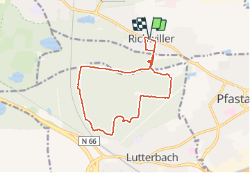
Trail Mountain bike of 7.2 km to be discovered at Grand Est, Haut-Rhin, Richwiller. This trail is proposed by jmkrust.
Description
Velo
Positioning
Country:
France
Region :
Grand Est
Department/Province :
Haut-Rhin
Municipality :
Richwiller
Location:
Unknown
Start:(Dec)
Start:(UTM)
371201 ; 5293231 (32T) N.
Comments