


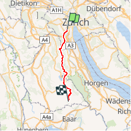
Zürich - Kappel a. Albis

hallauer
User

Length
19 km

Max alt
903 m

Uphill gradient
704 m
Km-Effort
28 km

Min alt
416 m

Downhill gradient
558 m
Boucle
No
Creation date :
2014-12-11 00:00:00.0
Updated on :
2014-12-11 00:00:00.0
6h19
Difficulty : Unknown

FREE GPS app for hiking
 SityTrail
IGN / Geographical institutes
SityTrail Plus
The world is yours!
About
Trail Other activity of 19 km to be discovered at Zurich, District Zurich, Zurich. This trail is proposed by hallauer.


Positioning
Country:
Switzerland
Region :
Zurich
Department/Province :
District Zurich
Municipality :
Zurich
Location:
Wiedikon
Start:(Dec)
Start:(UTM)
463743 ; 5245059 (32T) N.
Comments