Trail Walking Bouillon - 2021-04-29 16:59:52 Corr - Photo

2021-04-29 16:59:52 Corr

© OpenStreetMap contributors
Length
Length
16 km
Max alt
Max alt
384 m
Uphill gradient
Uphill gradient
571 m
Km-Effort
Km-Effort  
24 km
Min alt
Min alt
194 m
Downhill gradient
Downhill gradient
570 m
Boucle
Boucle
Yes
Creation date :
2021-05-15 15:35:38.192
Updated on :
2021-05-15 16:57:03.485

(0 Reviews)

Walking
Walking
5h21
Difficulty : Very difficult

Scan this QR Code to open this trail in the SityTrail application

FREE GPS app for hiking

Logo SityTrail SityTrail

IGN / Geographical institutes

Download SityTrail from the App Store Download SityTrail from Google Play

Logo SityTrail SityTrail Plus

The world is yours!

Download SityTrail from the App Store Download SityTrail from Google Play Download SityTrail on Huawei AppGallery

About

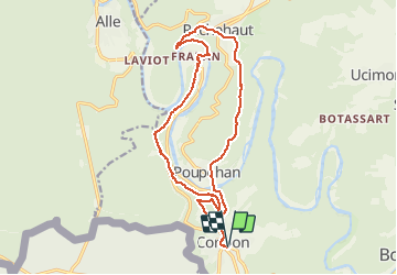
Trail Walking of 16 km to be discovered at Wallonia, Luxembourg, Bouillon. This trail is proposed by Luberon1963.

Description

Boucle passant par les crêtes de Frahan, Rochehaut et Poupehan avec quelques variantes par rapport aux circuits conventionnels balisés.
La dernière remontée de Poupehan vers Corbion en vaut la peine ;-)
Physique sans être extrême, vous dormirez probablement bien la nuit suivante !

Elevation profile

Positioning

Country:
Belgium
Region :
Wallonia
Department/Province :
Luxembourg
Municipality :
Bouillon
Location:
Corbion
Start:(UTM)
644682 ; 5517954 (31U) N.


Close
My subscriptions