


Boucle vae

mapomme
User

Length
50 km

Max alt
223 m

Uphill gradient
749 m
Km-Effort
60 km

Min alt
64 m

Downhill gradient
743 m
Boucle
Yes
Creation date :
2021-05-14 07:17:20.0
Updated on :
2021-05-17 12:59:41.863
2h50
Difficulty : Easy

FREE GPS app for hiking
 SityTrail
IGN / Geographical institutes
SityTrail Plus
The world is yours!
About
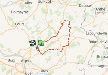
Trail Road bike of 50 km to be discovered at New Aquitaine, Lot-et-Garonne, Pont-du-Casse. This trail is proposed by mapomme.
Positioning
Country:
France
Region :
New Aquitaine
Department/Province :
Lot-et-Garonne
Municipality :
Pont-du-Casse
Location:
Unknown
Start:(Dec)
Start:(UTM)
313957 ; 4900916 (31T) N.
Comments