


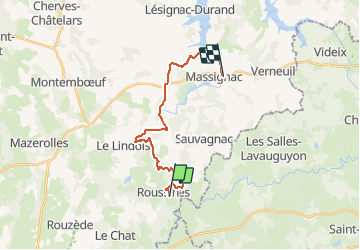
T02-Roussines à Massignac

topolino
User

Length
17.4 km

Max alt
282 m

Uphill gradient
279 m
Km-Effort
21 km

Min alt
192 m

Downhill gradient
288 m
Boucle
No
Creation date :
2021-05-17 15:10:23.008
Updated on :
2021-05-17 15:10:23.008
--
Difficulty : Unknown

FREE GPS app for hiking
 SityTrail
IGN / Geographical institutes
SityTrail Plus
The world is yours!
About
Trail Mountain bike of 17.4 km to be discovered at New Aquitaine, Charente, Roussines. This trail is proposed by topolino.
Positioning
Country:
France
Region :
New Aquitaine
Department/Province :
Charente
Municipality :
Roussines
Location:
Unknown
Start:(Dec)
Start:(UTM)
315100 ; 5065886 (31T) N.
Comments