


Steinbach

ROPPJP
User
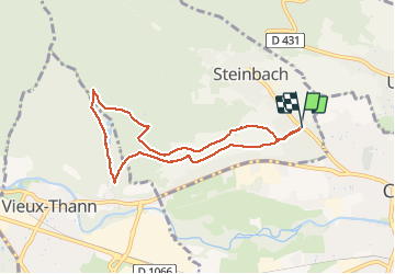

Length
7.1 km

Max alt
457 m

Uphill gradient
189 m
Km-Effort
9.6 km

Min alt
327 m

Downhill gradient
189 m
Boucle
Yes
Creation date :
2021-05-20 11:55:42.356
Updated on :
2021-05-20 14:25:25.087
2h29
Difficulty : Medium

FREE GPS app for hiking
 SityTrail
IGN / Geographical institutes
SityTrail Plus
The world is yours!
About
Trail Walking of 7.1 km to be discovered at Grand Est, Haut-Rhin, Steinbach. This trail is proposed by ROPPJP.
Photos


Positioning
Country:
France
Region :
Grand Est
Department/Province :
Haut-Rhin
Municipality :
Steinbach
Location:
Unknown
Start:(Dec)
Start:(UTM)
362352 ; 5297426 (32T) N.
Comments