


Le Mont Ventoux par le versant Sud

ARVIEU
User
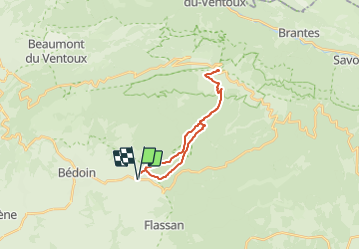

Length
22 km

Max alt
1910 m

Uphill gradient
1453 m
Km-Effort
41 km

Min alt
458 m

Downhill gradient
1453 m
Boucle
Yes
Creation date :
2021-06-05 05:41:47.761
Updated on :
2021-06-05 05:44:18.714
8h00
Difficulty : Very difficult

FREE GPS app for hiking
 SityTrail
IGN / Geographical institutes
SityTrail Plus
The world is yours!
About
Trail Walking of 22 km to be discovered at Provence-Alpes-Côte d'Azur, Vaucluse, Bédoin. This trail is proposed by ARVIEU.


Positioning
Country:
France
Region :
Provence-Alpes-Côte d'Azur
Department/Province :
Vaucluse
Municipality :
Bédoin
Location:
Unknown
Start:(Dec)
Start:(UTM)
677924 ; 4887638 (31T) N.
Comments