


tours des jas

mthomas30
User
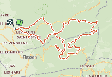

Length
32 km

Max alt
1104 m

Uphill gradient
1112 m
Km-Effort
47 km

Min alt
461 m

Downhill gradient
1111 m
Boucle
Yes
Creation date :
2021-06-05 06:27:08.062
Updated on :
2021-06-05 11:55:23.437
5h26
Difficulty : Difficult

FREE GPS app for hiking
 SityTrail
IGN / Geographical institutes
SityTrail Plus
The world is yours!
About
Trail Mountain bike of 32 km to be discovered at Provence-Alpes-Côte d'Azur, Vaucluse, Bédoin. This trail is proposed by mthomas30.
Positioning
Country:
France
Region :
Provence-Alpes-Côte d'Azur
Department/Province :
Vaucluse
Municipality :
Bédoin
Location:
Unknown
Start:(Dec)
Start:(UTM)
678028 ; 4887631 (31T) N.
Comments