


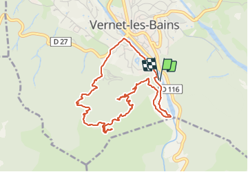
Col de Pena
© OpenStreetMap contributors


3h11
Difficulty : Medium


Length
5.4 km
Max alt
1051 m
Uphill gradient
429 m
Km-Effort
11.1 km
Min alt
643 m
Downhill gradient
430 m
Boucle
Yes
Creation date :
2021-06-06 09:47:18.876
Updated on :
2021-06-06 14:00:45.833
3h11
Difficulty : Medium
FREE GPS app for hiking
 SityTrail
IGN / Geographical institutes
SityTrail Plus
The world is yours!
About
Trail Walking of 5.4 km to be discovered at Occitania, Pyrénées-Orientales, Vernet-les-Bains. This trail is proposed by jean.marie.litzler@gmail.com.
Positioning
Country:
France
Region :
Occitania
Department/Province :
Pyrénées-Orientales
Municipality :
Vernet-les-Bains
Location:
Unknown
Start:(Dec)
Start:(UTM)
450006 ; 4710281 (31T) N.
Comments