


GR 653 - C

mitch1952
User
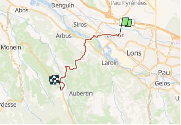

Length
14.6 km

Max alt
296 m

Uphill gradient
237 m
Km-Effort
17.8 km

Min alt
142 m

Downhill gradient
257 m
Boucle
No
Creation date :
2021-06-06 17:19:43.735
Updated on :
2022-06-08 13:56:52.576
4h02
Difficulty : Difficult

FREE GPS app for hiking
 SityTrail
IGN / Geographical institutes
SityTrail Plus
The world is yours!
About
Trail Walking of 14.6 km to be discovered at New Aquitaine, Pyrénées-Atlantiques, Lescar. This trail is proposed by mitch1952.
Positioning
Country:
France
Region :
New Aquitaine
Department/Province :
Pyrénées-Atlantiques
Municipality :
Lescar
Location:
Unknown
Start:(Dec)
Start:(UTM)
708399 ; 4801195 (30T) N.
Comments