


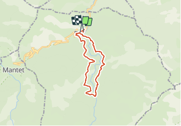
Boucle forestière de Py
© OpenStreetMap contributors


5h34
Difficulty : Very difficult


Length
13.2 km
Max alt
1543 m
Uphill gradient
680 m
Km-Effort
22 km
Min alt
971 m
Downhill gradient
721 m
Boucle
No
Creation date :
2021-06-07 09:16:23.266
Updated on :
2021-06-07 18:45:43.547
5h34
Difficulty : Very difficult
FREE GPS app for hiking
 SityTrail
IGN / Geographical institutes
SityTrail Plus
The world is yours!
About
Trail Walking of 13.2 km to be discovered at Occitania, Pyrénées-Orientales, Py. This trail is proposed by jean.marie.litzler@gmail.com.
Positioning
Country:
France
Region :
Occitania
Department/Province :
Pyrénées-Orientales
Municipality :
Py
Location:
Unknown
Start:(Dec)
Start:(UTM)
446795 ; 4705085 (31T) N.
Comments