


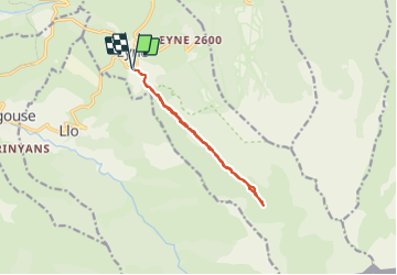
Vallée de l'Eyne
© OpenStreetMap contributors


3h21
Difficulty : Easy


Length
10.8 km
Max alt
2142 m
Uphill gradient
536 m
Km-Effort
17.9 km
Min alt
1603 m
Downhill gradient
536 m
Boucle
Yes
Creation date :
2021-06-09 10:26:16.584
Updated on :
2021-06-10 06:30:47.145
3h21
Difficulty : Easy
FREE GPS app for hiking
 SityTrail
IGN / Geographical institutes
SityTrail Plus
The world is yours!
About
Trail Walking of 10.8 km to be discovered at Occitania, Pyrénées-Orientales, Eyne. This trail is proposed by jean.marie.litzler@gmail.com.
Positioning
Country:
France
Region :
Occitania
Department/Province :
Pyrénées-Orientales
Municipality :
Eyne
Location:
Unknown
Start:(Dec)
Start:(UTM)
424528 ; 4702308 (31T) N.
Comments