


TRACE TRAVERSEE ENTIERE MATHILDE

harydh
User GUIDE
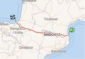

Length
664 km

Max alt
2987 m

Uphill gradient
41562 m
Km-Effort
1218 km

Min alt
4 m

Downhill gradient
41560 m
Boucle
No
Creation date :
2021-06-11 20:26:21.277
Updated on :
2021-06-11 20:42:11.934
276h46
Difficulty : Very difficult

FREE GPS app for hiking
 SityTrail
IGN / Geographical institutes
SityTrail Plus
The world is yours!
About
Trail Walking of 664 km to be discovered at Occitania, Pyrénées-Orientales, Banyuls-sur-Mer. This trail is proposed by harydh.
Positioning
Country:
France
Region :
Occitania
Department/Province :
Pyrénées-Orientales
Municipality :
Banyuls-sur-Mer
Location:
Unknown
Start:(Dec)
Start:(UTM)
510634 ; 4703280 (31T) N.
Comments