


montardon RS fait

LouisROGER
User GUIDE
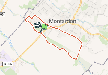

Length
3.8 km

Max alt
211 m

Uphill gradient
18 m
Km-Effort
4.1 km

Min alt
200 m

Downhill gradient
18 m
Boucle
Yes
Creation date :
2021-06-15 12:20:25.661
Updated on :
2021-06-15 14:14:16.312
1h53
Difficulty : Easy

FREE GPS app for hiking
 SityTrail
IGN / Geographical institutes
SityTrail Plus
The world is yours!
About
Trail Walking of 3.8 km to be discovered at New Aquitaine, Pyrénées-Atlantiques, Montardon. This trail is proposed by LouisROGER.
Positioning
Country:
France
Region :
New Aquitaine
Department/Province :
Pyrénées-Atlantiques
Municipality :
Montardon
Location:
Unknown
Start:(Dec)
Start:(UTM)
714177 ; 4804820 (30T) N.
Comments