


Jujols Sentier découverte
© OpenStreetMap contributors


3h34
Difficulty : Easy


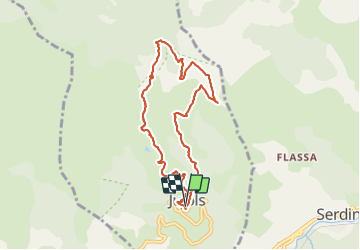
Length
8.7 km
Max alt
1491 m
Uphill gradient
559 m
Km-Effort
16.2 km
Min alt
946 m
Downhill gradient
565 m
Boucle
Yes
Creation date :
2021-06-15 08:42:24.018
Updated on :
2021-06-15 18:57:55.685
3h34
Difficulty : Easy
FREE GPS app for hiking
 SityTrail
IGN / Geographical institutes
SityTrail Plus
The world is yours!
About
Trail Walking of 8.7 km to be discovered at Occitania, Pyrénées-Orientales, Jujols. This trail is proposed by jean.marie.litzler@gmail.com.
Positioning
Country:
France
Region :
Occitania
Department/Province :
Pyrénées-Orientales
Municipality :
Jujols
Location:
Unknown
Start:(Dec)
Start:(UTM)
442115 ; 4713225 (31T) N.
Comments