


dB to 78

JPS73
User
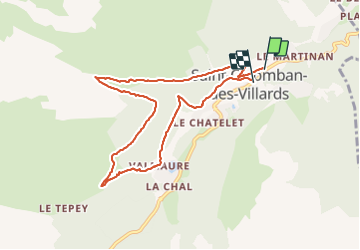

Length
8.6 km

Max alt
1470 m

Uphill gradient
446 m
Km-Effort
14.6 km

Min alt
1101 m

Downhill gradient
449 m
Boucle
No
Creation date :
2021-06-17 08:51:38.975
Updated on :
2021-06-17 13:19:02.584
2h59
Difficulty : Difficult

FREE GPS app for hiking
 SityTrail
IGN / Geographical institutes
SityTrail Plus
The world is yours!
About
Trail Walking of 8.6 km to be discovered at Auvergne-Rhône-Alpes, Savoy, Saint-Colomban-des-Villards. This trail is proposed by JPS73.
Positioning
Country:
France
Region :
Auvergne-Rhône-Alpes
Department/Province :
Savoy
Municipality :
Saint-Colomban-des-Villards
Location:
Unknown
Start:(Dec)
Start:(UTM)
282694 ; 5019521 (32T) N.
Comments