


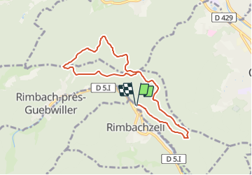
Rimbachzell - Col de Peternit - Chemin de Geiskopf - Munsteraeckerlé et retour

patrickbeyrath
User

Length
10 km

Max alt
661 m

Uphill gradient
295 m
Km-Effort
13.9 km

Min alt
442 m

Downhill gradient
293 m
Boucle
Yes
Creation date :
2021-06-18 05:27:40.415
Updated on :
2021-06-18 06:05:09.098
1h59
Difficulty : Medium

FREE GPS app for hiking
 SityTrail
IGN / Geographical institutes
SityTrail Plus
The world is yours!
About
Trail On foot of 10 km to be discovered at Grand Est, Haut-Rhin, Rimbach-près-Guebwiller. This trail is proposed by patrickbeyrath.
Positioning
Country:
France
Region :
Grand Est
Department/Province :
Haut-Rhin
Municipality :
Rimbach-près-Guebwiller
Location:
Unknown
Start:(Dec)
Start:(UTM)
363733 ; 5307232 (32T) N.
Comments