Trail Walking Montgeron - J 38 Montgeron la Pelouse, forêt de Sénart - Photo

J 38 Montgeron la Pelouse, forêt de Sénart

Club randonnées SERVON

© OpenStreetMap contributors
Length
Length
12.3 km
Max alt
Max alt
95 m
Uphill gradient
Uphill gradient
69 m
Km-Effort
Km-Effort  
13.2 km
Min alt
Min alt
76 m
Downhill gradient
Downhill gradient
69 m
Boucle
Boucle
Yes
Creation date :
2021-06-18 16:51:00.338
Updated on :
2023-03-25 10:58:11.13

(3 Reviews)

Walking
Walking
3h09
Difficulty : Medium

Scan this QR Code to open this trail in the SityTrail application

FREE GPS app for hiking

Logo SityTrail SityTrail

IGN / Geographical institutes

Download SityTrail from the App Store Download SityTrail from Google Play

Logo SityTrail SityTrail World

The world is yours!

Download SityTrail from the App Store Download SityTrail from Google Play Download SityTrail on Huawei AppGallery

About

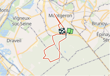
Trail Walking of 12.3 km to be discovered at Ile-de-France, Essonne, Montgeron. This trail is proposed by Les 1000 pattes.

Description

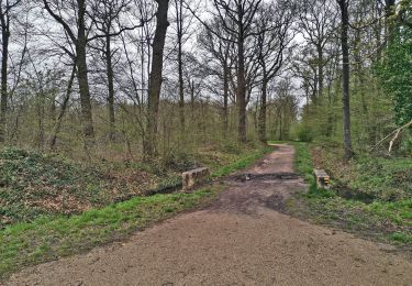
La Pelouse: lieu historique
Parking intersection carrefour de Montgeron avec route forestière Pierreuse
Trajet Servon--> Montgeron: 24km (25mn)

Elevation profile

Photos

Positioning

Country:
France
Region :
Ile-de-France
Department/Province :
Essonne
Municipality :
Montgeron
Location:
Unknown
Start:(Dec)
Start:(UTM)
460749 ; 5392821 (31U) N.

Comments

Please log in to post a review or rate the element


Trails nearby

Trail Walking Boussy-Saint-Antoine - GRP CV-IDF 04 - Photo
Walking
clalaur

Walking

Difficult
(1)
Boussy-Saint-Antoine, Ile-de-France, Essonne, France
16.8 km | 18.6 km-effort
4h 13min
No
Trail On foot Brunoy - L 39 Brunoy, les bords de l'Yerres - Photo
On foot

On foot

Very easy
(4)
Brunoy, Ile-de-France, Essonne, France
5.4 km | 6.1 km-effort
1h 49min
Yes
Trail On foot Quincy-sous-Sénart - J 77 Tigery, Allée Royale - Photo
On foot

On foot

Medium
(2)
Quincy-sous-Sénart, Ile-de-France, Essonne, France
10.6 km | 12 km-effort
2h 44min
Yes
Trail On foot Boussy-Saint-Antoine - L 32: Boussy St Antoine l'Yerres et le Gord - Photo
On foot

On foot

Very easy
(3)
Boussy-Saint-Antoine, Ile-de-France, Essonne, France
6.2 km | 7.2 km-effort
1h 38min
Yes
Trail Walking Yerres - J 43  Yerres Parc Caillebotte, île des Prévôts - Photo
Walking

Walking

Medium
(2)
Yerres, Ile-de-France, Essonne, France
11.4 km | 13.1 km-effort
2h 59min
Yes
Trail Walking Montgeron - JC 28 Sénart, Champrosay, Soisy sur Seine - Photo
Walking

Walking

Difficult
(1)
Montgeron, Ile-de-France, Essonne, France
21 km | 24 km-effort
5h 21min
Yes
Trail Walking Soisy-sur-Seine - Sénart arbres remarquables 1/2 - Photo
Walking
dmatignon

Walking

Easy
(1)
Soisy-sur-Seine, Ile-de-France, Essonne, France
12.2 km | 13.1 km-effort
2h 55min
Yes
Trail Walking Draveil - Port aux Cerises - Ablon 21 km - Photo
Walking
GUIDE
jeanmarcMasson

Walking

Very difficult
(1)
Draveil, Ile-de-France, Essonne, France
22 km | 25 km-effort
4h 51min
Yes
Trail Walking Quincy-sous-Sénart - SityTrail - 3526683 - foret-de-senart-xetang-dr-tigery - Photo
Walking
fjp

Walking

Difficult
(1)
Quincy-sous-Sénart, Ile-de-France, Essonne, France
13.5 km | 15.2 km-effort
3h 28min
Yes


Close
My subscriptions