Trail On foot Boussy-Saint-Antoine - L 32: Boussy St Antoine l'Yerres et le Gord - Photo

L 32: Boussy St Antoine l'Yerres et le Gord

Club randonnées SERVON

© OpenStreetMap contributors
Length
Length
6.2 km
Max alt
Max alt
83 m
Uphill gradient
Uphill gradient
76 m
Km-Effort
Km-Effort  
7.2 km
Min alt
Min alt
41 m
Downhill gradient
Downhill gradient
77 m
Boucle
Boucle
Yes
Creation date :
2021-06-08 12:53:06.019
Updated on :
2022-11-30 15:00:24.413

(3 Reviews)

On foot
On foot
1h38
Difficulty : Very easy

Scan this QR Code to open this trail in the SityTrail application

FREE GPS app for hiking

Logo SityTrail SityTrail

IGN / Geographical institutes

Download SityTrail from the App Store Download SityTrail from Google Play

Logo SityTrail SityTrail World

The world is yours!

Download SityTrail from the App Store Download SityTrail from Google Play Download SityTrail on Huawei AppGallery

About

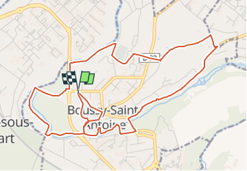
Trail On foot of 6.2 km to be discovered at Ile-de-France, Essonne, Boussy-Saint-Antoine. This trail is proposed by Les 1000 pattes.

Description

Parking Rue de Rochopt à Boussy St Antoine (en face de la piscine)
Trajet Servon-->Boussy ( 7km:12mn)

Elevation profile

Photos

Points of interest

Point of interest Boussy-Saint-Antoine - raccourcir rando - Photo
cramcl50
BOUSSY-SAINT-ANTOINE 

Positioning

Country:
France
Region :
Ile-de-France
Department/Province :
Essonne
Municipality :
Boussy-Saint-Antoine
Location:
Unknown
Start:(UTM)
465166 ; 5393186 (31U) N.

Comments

Please log in to post a review or rate the element


Trails nearby

Trail Walking Boussy-Saint-Antoine - GRP CV-IDF 04 - Photo
Walking
clalaur

Walking

Difficult
(1)
Boussy-Saint-Antoine, Ile-de-France, Essonne, France
16.8 km | 18.6 km-effort
4h 13min
No
Trail Walking Mandres-les-Roses - J 26 Mandres, Boussy , Brunoy le chemin des fresques  - Photo
Walking

Walking

Medium
(2)
Mandres-les-Roses, Ile-de-France, Val-de-Marne, France
12.2 km | 13.8 km-effort
3h 7min
Yes
Trail On foot Servon - J 01  11.97 km  les 5 châteaux  - Photo
On foot

On foot

Medium
(1)
Servon, Ile-de-France, Seine-et-Marne, France
11.7 km | 13.2 km-effort
3h 3min
Yes
Trail On foot Servon - R 04 - 8 km -  Servon, Santeny, Servon - Photo
On foot

On foot

Very difficult
(4)
Servon, Ile-de-France, Seine-et-Marne, France
7.9 km | 9.1 km-effort
2h 3min
Yes
Trail Walking Yerres - BM Foret Regionale de Grobois 10km - Photo
Walking
GUIDE
jeanmarcMasson

Walking

Medium
(1)
Yerres, Ile-de-France, Essonne, France
10.4 km | 11 km-effort
2h 30min
Yes
Trail Walking Yerres - BM Foret Regionale Grosbois 10km - Photo
Walking
GUIDE
jeanmarcMasson

Walking

Medium
(1)
Yerres, Ile-de-France, Essonne, France
9.8 km | 10.5 km-effort
2h 23min
Yes
Trail On foot Brunoy - L 39 Brunoy, les bords de l'Yerres - Photo
On foot

On foot

Very easy
(4)
Brunoy, Ile-de-France, Essonne, France
5.4 km | 6.1 km-effort
1h 49min
Yes
Trail Walking Montgeron - J 38 Montgeron la Pelouse, forêt de Sénart - Photo
Walking

Walking

Medium
(3)
Montgeron, Ile-de-France, Essonne, France
12.3 km | 13.2 km-effort
3h 9min
Yes
Trail On foot Quincy-sous-Sénart - J 77 Tigery, Allée Royale - Photo
On foot

On foot

Medium
(2)
Quincy-sous-Sénart, Ile-de-France, Essonne, France
10.6 km | 12 km-effort
2h 44min
Yes


Close
My subscriptions