Trail Mountain bike Coly-Saint-Amand - Coly Saint Amand 3 - Photo
 Jéjé
Jéjé

User

© OpenStreetMap contributors
Length
Length
43 km
Max alt
Max alt
287 m
Uphill gradient
Uphill gradient
1091 m
Km-Effort
Km-Effort  
58 km
Min alt
Min alt
110 m
Downhill gradient
Downhill gradient
1082 m
Boucle
Boucle
Yes
Creation date :
2021-06-18 20:26:41.509
Updated on :
2021-09-16 18:03:29.045

(0 Reviews)

Mountain bike
Mountain bike
3h38
Difficulty : Very difficult

Scan this QR Code to open this trail in the SityTrail application

FREE GPS app for hiking

Logo SityTrail SityTrail

IGN / Geographical institutes

Download SityTrail from the App Store Download SityTrail from Google Play

Logo SityTrail SityTrail World

The world is yours!

Download SityTrail from the App Store Download SityTrail from Google Play Download SityTrail on Huawei AppGallery

About

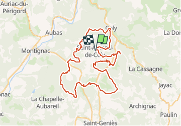
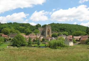
Trail Mountain bike of 43 km to be discovered at New Aquitaine, Dordogne, Coly-Saint-Amand. This trail is proposed by Jéjé.

Description

43 Kms , dénivelé 1091 m

Elevation profile

Positioning

Country:
France
Region :
New Aquitaine
Department/Province :
Dordogne
Municipality :
Coly-Saint-Amand
Location:
Unknown
Start:(UTM)
362028 ; 4991505 (31T) N.

Trails nearby

Trail Walking La Cassagne - rivière de Coly - Photo
Walking
GuyLab

Walking

Very easy
La Cassagne, New Aquitaine, Dordogne, France
5.4 km | 6.8 km-effort
2h 12min
Yes
Trail Walking Coly-Saint-Amand - vezere_19 - Photo
Walking
fanthou

Walking

Medium
(3)
Coly-Saint-Amand, New Aquitaine, Dordogne, France
8.2 km | 11.1 km-effort
2h 22min
Yes
Trail Walking Coly-Saint-Amand - coly300322 - Photo
Walking
Reider

Walking

Difficult
Coly-Saint-Amand, New Aquitaine, Dordogne, France
11.4 km | 14.5 km-effort
3h 22min
Yes
Trail Walking Aubas - Circuit des trois châteaux - Photo
Walking
CC.RIDER

Walking

Difficult
(2)
Aubas, New Aquitaine, Dordogne, France
13.7 km | 18.1 km-effort
4h 7min
Yes
Trail Walking Coly-Saint-Amand - Saint Amand de Coly  - Photo
Walking
alainjoseph6

Walking

Easy
Coly-Saint-Amand, New Aquitaine, Dordogne, France
1.6 km | 2.4 km-effort
1h 17min
Yes
Trail Walking Saint-Geniès - De Vialard à Saint Amand de Coly - Photo
Walking
tracegps

Walking

Medium
Saint-Geniès, New Aquitaine, Dordogne, France
5.9 km | 8.1 km-effort
1h 49min
No
Trail Mountain bike Coly-Saint-Amand - Dordogne 1 - Photo
Mountain bike
kerdi17

Mountain bike

Coly-Saint-Amand, New Aquitaine, Dordogne, France
18.4 km | 22 km-effort
1h 30min
Yes
Trail Walking Coly-Saint-Amand - aiOn- - Photo
Walking
Galandos

Walking

Medium
Coly-Saint-Amand, New Aquitaine, Dordogne, France
5.5 km | 7.1 km-effort
2h 2min
Yes
Trail Walking Coly-Saint-Amand - boucle du Coly - Photo
Walking
NICOLEROBERT

Walking

Medium
Coly-Saint-Amand, New Aquitaine, Dordogne, France
12.3 km | 16.3 km-effort
3h 36min
Yes


Close
My subscriptions