Trail Walking Combronde - Puy Servier - Photo
 Gegetop
Gegetop

User

© OpenStreetMap contributors
Length
Length
6.3 km
Max alt
Max alt
629 m
Uphill gradient
Uphill gradient
223 m
Km-Effort
Km-Effort  
9.3 km
Min alt
Min alt
418 m
Downhill gradient
Downhill gradient
224 m
Boucle
Boucle
Yes
Creation date :
2014-12-10 00:00:00.0
Updated on :
2014-12-10 00:00:00.0

(2 Reviews)

Walking
Walking
2h00
Difficulty : Medium

Scan this QR Code to open this trail in the SityTrail application

FREE GPS app for hiking

Logo SityTrail SityTrail

IGN / Geographical institutes

Download SityTrail from the App Store Download SityTrail from Google Play

Logo SityTrail SityTrail World

The world is yours!

Download SityTrail from the App Store Download SityTrail from Google Play Download SityTrail on Huawei AppGallery

About

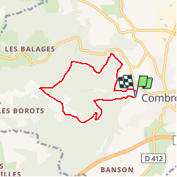
Trail Walking of 6.3 km to be discovered at Auvergne-Rhône-Alpes, Puy-de-Dôme, Combronde. This trail is proposed by Gegetop.

Description

Balade sympa sur les hauteurs boisées de Combronde.
Le sentier se ferme par la végétation un peu avant Combe Grand, attention donc à ne pas descendre vers le ruisseau.

Elevation profile

Positioning

Country:
France
Region :
Auvergne-Rhône-Alpes
Department/Province :
Puy-de-Dôme
Municipality :
Combronde
Location:
Unknown
Start:(UTM)
506209 ; 5092047 (31T) N.

Comments

Please log in to post a review or rate the element


une bonne partie du chemin n'est pas entretenue cependant ca passe quand même. dans les lacets au début du parcours ne pas tenir compte du tracé pour un lacets. continuez sur le chemin le mieux entretenu et vous retrouverez rapidement le tracé. très belles vue sur la chaîne des puys quand on arrive sur les hauteurs.


Très intuitive cette appli est la meilleure et le catalogue de randonnées est bien utile quand on découvre une région.


Trails nearby

Trail Walking Loubeyrat - Le roc du diable - Prompsat - Photo
Walking
Gegetop

Walking

Medium
(1)
Loubeyrat, Auvergne-Rhône-Alpes, Puy-de-Dôme, France
9.5 km | 13.4 km-effort
2h 20min
Yes
Trail Walking Teilhède - Teilhede - Photo
Walking
Gegetop

Walking

Easy
(1)
Teilhède, Auvergne-Rhône-Alpes, Puy-de-Dôme, France
6.5 km | 8.7 km-effort
1h 38min
Yes
Trail Walking Gimeaux - Chemin de Fontête - Photo
Walking
Gegetop

Walking

Easy
(2)
Gimeaux, Auvergne-Rhône-Alpes, Puy-de-Dôme, France
8.6 km | 11.9 km-effort
2h 6min
Yes
Trail Walking Artonne - D'Artonne à Chaptuzat - Photo
Walking
tracegps

Walking

Difficult
(1)
Artonne, Auvergne-Rhône-Alpes, Puy-de-Dôme, France
23 km | 30 km-effort
5h 49min
Yes
Trail Walking Artonne - La croix des Rameaux - Photo
Walking
tracegps

Walking

Medium
(2)
Artonne, Auvergne-Rhône-Alpes, Puy-de-Dôme, France
11.2 km | 14.3 km-effort
2h 45min
Yes
Trail On foot Artonne - La Croix des Rameaux et le Puy St Jean - Photo
On foot
PRO

On foot

Easy
Artonne, Auvergne-Rhône-Alpes, Puy-de-Dôme, France
10.5 km | 13.6 km-effort
3h 5min
Yes
Trail On foot Combronde - La Pierre Branlante - Photo
On foot
PRO

On foot

Easy
Combronde, Auvergne-Rhône-Alpes, Puy-de-Dôme, France
7.7 km | 11 km-effort
2h 29min
No
Trail On foot Gimeaux - Le Sentier des Trois Clochers - Photo
On foot
PRO

On foot

Easy
Gimeaux, Auvergne-Rhône-Alpes, Puy-de-Dôme, France
6.6 km | 8.8 km-effort
2h 0min
Yes
Trail On foot Prompsat - Le tour du puy de Gramont - Photo
On foot
PRO

On foot

Easy
Prompsat, Auvergne-Rhône-Alpes, Puy-de-Dôme, France
9.4 km | 12.7 km-effort
2h 52min
Yes


Close
My subscriptions