Trail Walking Teilhède - Teilhede - Photo
 Gegetop
Gegetop

User

© OpenStreetMap contributors
Length
Length
6.5 km
Max alt
Max alt
525 m
Uphill gradient
Uphill gradient
167 m
Km-Effort
Km-Effort  
8.7 km
Min alt
Min alt
372 m
Downhill gradient
Downhill gradient
169 m
Boucle
Boucle
Yes
Creation date :
2014-12-10 00:00:00.0
Updated on :
2014-12-10 00:00:00.0

(1 Reviews)

Walking
Walking
1h38
Difficulty : Easy

Scan this QR Code to open this trail in the SityTrail application

FREE GPS app for hiking

Logo SityTrail SityTrail

IGN / Geographical institutes

Download SityTrail from the App Store Download SityTrail from Google Play

Logo SityTrail SityTrail World

The world is yours!

Download SityTrail from the App Store Download SityTrail from Google Play Download SityTrail on Huawei AppGallery

About

Trail Walking of 6.5 km to be discovered at Auvergne-Rhône-Alpes, Puy-de-Dôme, Teilhède. This trail is proposed by Gegetop.

Description

Petite balade sympa avec joli point de vue depuis le Puy de Montaury.

Elevation profile

Photos

Positioning

Country:
France
Region :
Auvergne-Rhône-Alpes
Department/Province :
Puy-de-Dôme
Municipality :
Teilhède
Location:
Unknown
Start:(UTM)
505611 ; 5089195 (31T) N.

Comments

Please log in to post a review or rate the element


bien


Trails nearby

Trail On foot Loubeyrat - La Vallee des Prades - Photo
On foot
PRO

On foot

Easy
(1)
Loubeyrat, Auvergne-Rhône-Alpes, Puy-de-Dôme, France
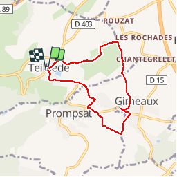
11.1 km | 15.6 km-effort
3h 33min
Yes
Trail Walking Loubeyrat - Le roc du diable - Prompsat - Photo
Walking
Gegetop

Walking

Medium
(1)
Loubeyrat, Auvergne-Rhône-Alpes, Puy-de-Dôme, France
9.5 km | 13.4 km-effort
2h 20min
Yes
Trail Walking Gimeaux - Chemin de Fontête - Photo
Walking
Gegetop

Walking

Easy
(2)
Gimeaux, Auvergne-Rhône-Alpes, Puy-de-Dôme, France
8.6 km | 11.9 km-effort
2h 6min
Yes
Trail Walking Châtel-Guyon - Les Briffons-Bois d'Agnat - Photo
Walking
Gegetop

Walking

Easy
(2)
Châtel-Guyon, Auvergne-Rhône-Alpes, Puy-de-Dôme, France
10.6 km | 14.8 km-effort
3h 14min
Yes
Trail Walking Châtel-Guyon - Chazeron sans souci - Photo
Walking
Gegetop

Walking

Easy
(1)
Châtel-Guyon, Auvergne-Rhône-Alpes, Puy-de-Dôme, France
6.6 km | 9.7 km-effort
1h 45min
Yes
Trail Walking Châtel-Guyon - Boucle de Rochepradière en passant par Douhady - Photo
Walking
Gegetop

Walking

Easy
(1)
Châtel-Guyon, Auvergne-Rhône-Alpes, Puy-de-Dôme, France
6.7 km | 9.7 km-effort
2h 6min
Yes
Trail On foot Combronde - La Pierre Branlante - Photo
On foot
PRO

On foot

Easy
Combronde, Auvergne-Rhône-Alpes, Puy-de-Dôme, France
7.7 km | 11 km-effort
2h 29min
No
Trail On foot Châtel-Guyon - La Vallée du Sans-Souci - Photo
On foot
PRO

On foot

Easy
Châtel-Guyon, Auvergne-Rhône-Alpes, Puy-de-Dôme, France
4.4 km | 6.5 km-effort
1h 28min
Yes
Trail Walking Combronde - Puy Servier - Photo
Walking
Gegetop

Walking

Medium
(2)
Combronde, Auvergne-Rhône-Alpes, Puy-de-Dôme, France
6.3 km | 9.3 km-effort
2h 0min
Yes


Close
My subscriptions