


esterençuby G3 FAIT

LouisROGER
User GUIDE
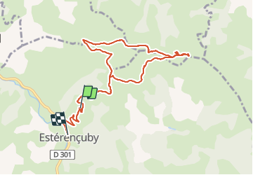

Length
10.7 km

Max alt
725 m

Uphill gradient
390 m
Km-Effort
16.4 km

Min alt
231 m

Downhill gradient
554 m
Boucle
No
Creation date :
2021-06-25 08:02:00.377
Updated on :
2021-06-25 13:29:50.177
5h24
Difficulty : Difficult

FREE GPS app for hiking
 SityTrail
IGN / Geographical institutes
SityTrail Plus
The world is yours!
About
Trail Walking of 10.7 km to be discovered at New Aquitaine, Pyrénées-Atlantiques, Estérençuby. This trail is proposed by LouisROGER.
Positioning
Country:
France
Region :
New Aquitaine
Department/Province :
Pyrénées-Atlantiques
Municipality :
Estérençuby
Location:
Unknown
Start:(Dec)
Start:(UTM)
647050 ; 4774522 (30T) N.
Comments