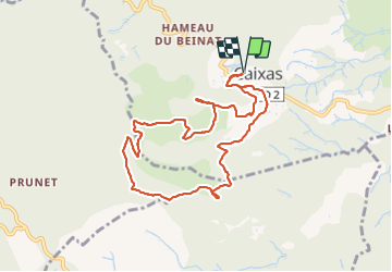
Caixas Mont Héléna
© OpenStreetMap contributors


4h01
Difficulty : Easy


Length
10.3 km
Max alt
772 m
Uphill gradient
435 m
Km-Effort
16.1 km
Min alt
383 m
Downhill gradient
433 m
Boucle
Yes
Creation date :
2021-06-24 08:10:19.061
Updated on :
2021-06-26 08:13:02.124
4h01
Difficulty : Easy
FREE GPS app for hiking
 SityTrail
IGN / Geographical institutes
SityTrail Plus
The world is yours!
About
Trail Walking of 10.3 km to be discovered at Occitania, Pyrénées-Orientales, Caixas. This trail is proposed by jean.marie.litzler@gmail.com.
Positioning
Country:
France
Region :
Occitania
Department/Province :
Pyrénées-Orientales
Municipality :
Caixas
Location:
Unknown
Start:(Dec)
Start:(UTM)
473808 ; 4714549 (31T) N.
Comments