


Gr10T1 nettoyé

LouisROGER
User GUIDE

Length
5.7 km

Max alt
1250 m

Uphill gradient
282 m
Km-Effort
9.2 km

Min alt
1036 m

Downhill gradient
194 m
Boucle
No
Creation date :
2021-06-26 07:12:43.888
Updated on :
2021-06-28 19:23:03.55
4h14
Difficulty : Medium

FREE GPS app for hiking
 SityTrail
IGN / Geographical institutes
SityTrail Plus
The world is yours!
About
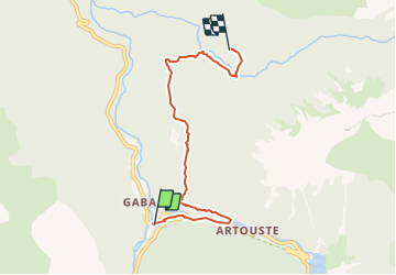
Trail Walking of 5.7 km to be discovered at New Aquitaine, Pyrénées-Atlantiques, Laruns. This trail is proposed by LouisROGER.
Photos


Positioning
Country:
France
Region :
New Aquitaine
Department/Province :
Pyrénées-Atlantiques
Municipality :
Laruns
Location:
Unknown
Start:(Dec)
Start:(UTM)
710166 ; 4751466 (30T) N.
Comments