


2021-06-26 Rando GR5 Aubure Étang du Devin Reel

holtzv
User GUIDE
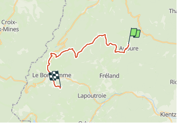

Length
20 km

Max alt
1226 m

Uphill gradient
890 m
Km-Effort
31 km

Min alt
677 m

Downhill gradient
699 m
Boucle
No
Creation date :
2021-06-26 07:34:00.581
Updated on :
2021-06-27 20:07:36.963
6h06
Difficulty : Medium

FREE GPS app for hiking
 SityTrail
IGN / Geographical institutes
SityTrail Plus
The world is yours!
About
Trail Walking of 20 km to be discovered at Grand Est, Haut-Rhin, Aubure. This trail is proposed by holtzv.
Positioning
Country:
France
Region :
Grand Est
Department/Province :
Haut-Rhin
Municipality :
Aubure
Location:
Unknown
Start:(Dec)
Start:(UTM)
367875 ; 5340223 (32U) N.
Comments