


femma-plan du lac

m261212
User
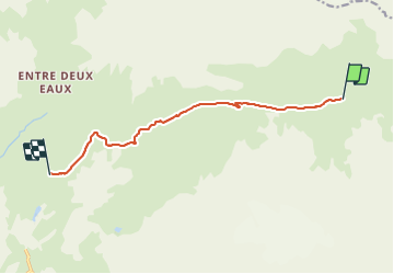

Length
9.2 km

Max alt
2418 m

Uphill gradient
268 m
Km-Effort
12.7 km

Min alt
2194 m

Downhill gradient
262 m
Boucle
No
Creation date :
2021-06-27 15:15:24.367
Updated on :
2021-06-27 15:18:59.05
2h53
Difficulty : Difficult

FREE GPS app for hiking
 SityTrail
IGN / Geographical institutes
SityTrail Plus
The world is yours!
About
Trail Walking of 9.2 km to be discovered at Auvergne-Rhône-Alpes, Savoy, Val-Cenis. This trail is proposed by m261212.
Positioning
Country:
France
Region :
Auvergne-Rhône-Alpes
Department/Province :
Savoy
Municipality :
Val-Cenis
Location:
Termignon
Start:(Dec)
Start:(UTM)
337779 ; 5025337 (32T) N.
Comments