


Chichiliane - Platary

lionelnottat
User
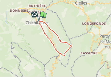

Length
9.3 km

Max alt
1574 m

Uphill gradient
616 m
Km-Effort
17.5 km

Min alt
964 m

Downhill gradient
618 m
Boucle
Yes
Creation date :
2021-06-27 19:03:41.968
Updated on :
2021-06-27 19:04:19.711
3h59
Difficulty : Difficult

FREE GPS app for hiking
 SityTrail
IGN / Geographical institutes
SityTrail Plus
The world is yours!
About
Trail Walking of 9.3 km to be discovered at Auvergne-Rhône-Alpes, Isère, Chichilianne. This trail is proposed by lionelnottat.
Positioning
Country:
France
Region :
Auvergne-Rhône-Alpes
Department/Province :
Isère
Municipality :
Chichilianne
Location:
Unknown
Start:(Dec)
Start:(UTM)
703680 ; 4965313 (31T) N.
Comments