


balisage GR10UetT30062021

LouisROGER
User GUIDE
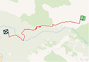

Length
6.6 km

Max alt
1681 m

Uphill gradient
119 m
Km-Effort
10 km

Min alt
1095 m

Downhill gradient
657 m
Boucle
No
Creation date :
2021-06-30 12:53:11.776
Updated on :
2021-06-30 17:30:09.591
2h27
Difficulty : Medium

FREE GPS app for hiking
 SityTrail
IGN / Geographical institutes
SityTrail Plus
The world is yours!
About
Trail Walking of 6.6 km to be discovered at New Aquitaine, Pyrénées-Atlantiques, Laruns. This trail is proposed by LouisROGER.
Positioning
Country:
France
Region :
New Aquitaine
Department/Province :
Pyrénées-Atlantiques
Municipality :
Laruns
Location:
Unknown
Start:(Dec)
Start:(UTM)
714309 ; 4754438 (30T) N.
Comments