


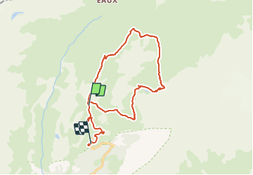
73 - Val Cenis Termignon Pkg Bellecombe

chris13370
User

Length
16.4 km

Max alt
2771 m

Uphill gradient
549 m
Km-Effort
25 km

Min alt
2037 m

Downhill gradient
810 m
Boucle
No
Creation date :
2021-06-28 07:09:57.355
Updated on :
2021-07-01 07:03:00.721
4h08
Difficulty : Medium

FREE GPS app for hiking
 SityTrail
IGN / Geographical institutes
SityTrail Plus
The world is yours!
About
Trail Walking of 16.4 km to be discovered at Auvergne-Rhône-Alpes, Savoy, Val-Cenis. This trail is proposed by chris13370.
Description
Boucle depuis le Pkg de Bellecombe
au col de Lanserlia (2791 m )
les lacs, refuge du plan du lac.
Photos


Positioning
Country:
France
Region :
Auvergne-Rhône-Alpes
Department/Province :
Savoy
Municipality :
Val-Cenis
Location:
Termignon
Start:(Dec)
Start:(UTM)
329892 ; 5021781 (32T) N.
Comments