Trail Walking Trient - TMB 09 - Trient -> Tréléchamp - Photo

TMB 09 - Trient -> Tréléchamp

 uru2010
uru2010

User

© OpenStreetMap contributors
Length
Length
13.7 km
Max alt
Max alt
2208 m
Uphill gradient
Uphill gradient
1058 m
Km-Effort
Km-Effort  
27 km
Min alt
Min alt
1280 m
Downhill gradient
Downhill gradient
941 m
Boucle
Boucle
No
Creation date :
2021-07-01 06:17:12.574
Updated on :
2022-05-08 14:55:09.953

(0 Reviews)

Walking
Walking
6h46
Difficulty : Difficult

Scan this QR Code to open this trail in the SityTrail application

FREE GPS app for hiking

Logo SityTrail SityTrail

IGN / Geographical institutes

Download SityTrail from the App Store Download SityTrail from Google Play

Logo SityTrail SityTrail World

The world is yours!

Download SityTrail from the App Store Download SityTrail from Google Play Download SityTrail on Huawei AppGallery

About

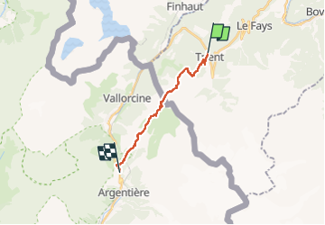
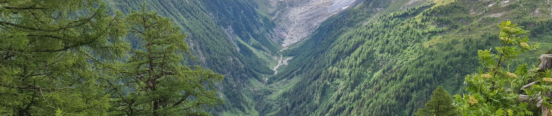
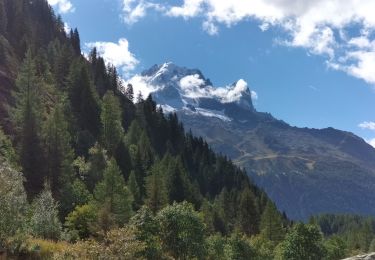
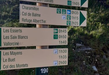
Trail Walking of 13.7 km to be discovered at Valais/Wallis, Martigny, Trient. This trail is proposed by uru2010.

Description

Départ : Hôtel La Grande Ourse, Trient.
Arrivée : Auberge La Boerne, 288 chemin de Tréléchamps. Tél : 04 50 54 05 14.

Randonnée faite le 1/7/2021.
Durée suivant le guide : 6h35. Ma durée réelle : 6h45.

Elevation profile

Photos

Positioning

Country:
Switzerland
Region :
Valais/Wallis
Department/Province :
Martigny
Municipality :
Trient
Location:
Unknown
Start:(UTM)
344829 ; 5102451 (32T) N.

Trails nearby

Trail Mountain bike Trient - Tour du Mont Blanc VTT - La Forclaz à La Fouly - Photo
Mountain bike
tracegps

Mountain bike

Difficult
(1)
Trient, Valais/Wallis, Martigny, Switzerland
31 km | 52 km-effort
3h 49min
No
Trail Touring skiing Finhaut - pointe de la terrasse  - Photo
Touring skiing
carton-fils@orange.fr

Touring skiing

Very easy
Finhaut, Valais/Wallis, Saint-Maurice, Switzerland
8.7 km | 19 km-effort
3h 14min
No
Trail Walking Chamonix-Mont-Blanc - TMB8 CAF 24 - Photo
Walking
reneperrin

Walking

Very difficult
Chamonix-Mont-Blanc, Auvergne-Rhône-Alpes, Upper Savoy, France
17.5 km | 33 km-effort
7h 33min
No
Trail Walking Vallorcine - téléphérique Vallorcine,col de Balme,aiguillettes des Posettes Montroc - Photo
Walking
marianne guichoux

Walking

Easy
Vallorcine, Auvergne-Rhône-Alpes, Upper Savoy, France
11.2 km | 19.4 km-effort
3h 28min
No
Trail On foot Vallorcine - Chalet de Loriaz - Photo
On foot
PRO

On foot

Medium
Vallorcine, Auvergne-Rhône-Alpes, Upper Savoy, France
13.6 km | 26 km-effort
5h 55min
Yes
Trail On foot Trient - Sentier des Alpages - Photo
On foot
PRO

On foot

Medium
Trient, Valais/Wallis, Martigny, Switzerland
11.4 km | 24 km-effort
5h 31min
Yes
Trail Walking Chamonix-Mont-Blanc - CHAMONIX ... Col de Balme & Aiguillettes des Posettes. - Photo
Walking
GerardBouche

Walking

Difficult
Chamonix-Mont-Blanc, Auvergne-Rhône-Alpes, Upper Savoy, France
10.3 km | 17.2 km-effort
3h 26min
No
Trail Walking Vallorcine - Vallorcine a la cascade de Barberine - Photo
Walking
Marie-Claire-mcp

Walking

Very easy
Vallorcine, Auvergne-Rhône-Alpes, Upper Savoy, France
6.6 km | 9.4 km-effort
2h 8min
Yes
Trail Walking Chamonix-Mont-Blanc - CHAMONIX (Croix de Fer) - Photo
Walking
GerardBouche

Walking

Medium
Chamonix-Mont-Blanc, Auvergne-Rhône-Alpes, Upper Savoy, France
10.6 km | 19 km-effort
3h 42min
No


Close
My subscriptions