


Jarrier - le Grand Chatelard

laurentnecca
User
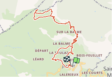

Length
13.6 km

Max alt
2131 m

Uphill gradient
1103 m
Km-Effort
28 km

Min alt
1032 m

Downhill gradient
1088 m
Boucle
Yes
Creation date :
2021-07-02 04:58:11.494
Updated on :
2021-07-02 11:30:00.237
6h03
Difficulty : Very difficult

FREE GPS app for hiking
 SityTrail
IGN / Geographical institutes
SityTrail Plus
The world is yours!
About
Trail Walking of 13.6 km to be discovered at Auvergne-Rhône-Alpes, Savoy, Jarrier. This trail is proposed by laurentnecca.
Positioning
Country:
France
Region :
Auvergne-Rhône-Alpes
Department/Province :
Savoy
Municipality :
Jarrier
Location:
Unknown
Start:(Dec)
Start:(UTM)
289715 ; 5017480 (32T) N.
Comments