Trail Walking Montaudin - Le taillis de Pouillé - Photo

Le taillis de Pouillé

© OpenStreetMap contributors
Length
Length
12.5 km
Max alt
Max alt
227 m
Uphill gradient
Uphill gradient
145 m
Km-Effort
Km-Effort  
14.4 km
Min alt
Min alt
172 m
Downhill gradient
Downhill gradient
146 m
Boucle
Boucle
Yes
Creation date :
2014-12-10 00:00:00.0
Updated on :
2014-12-10 00:00:00.0

(1 Reviews)

Walking
Walking
3h10
Difficulty : Easy

Scan this QR Code to open this trail in the SityTrail application

FREE GPS app for hiking

Logo SityTrail SityTrail

IGN / Geographical institutes

Download SityTrail from the App Store Download SityTrail from Google Play

Logo SityTrail SityTrail World

The world is yours!

Download SityTrail from the App Store Download SityTrail from Google Play Download SityTrail on Huawei AppGallery

About

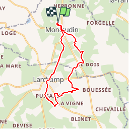
Trail Walking of 12.5 km to be discovered at Pays de la Loire, Mayenne, Montaudin. This trail is proposed by neoroll44.

Description

Depuis le plan d'eau de Montaudin, rejoindre Larchamp et remonter par le taillis (panneaux d'information sur la vie locale autrefois) puis le GR de pays.

Elevation profile

Positioning

Country:
France
Region :
Pays de la Loire
Department/Province :
Mayenne
Municipality :
Montaudin
Location:
Unknown
Start:(UTM)
648714 ; 5361492 (30U) N.

Comments

Please log in to post a review or rate the element


Encore en phase d essai 2 sorties de 65 km programmées dans la région Mayenne avant la rando le top !?? fiable et facile d utilisation ( prévoir une batterie de secours sur Iphone sur les longues randos !) je vais faire le pas pour l achat .


Trails nearby

Trail Mountain bike Larchamp - Larchamp Ernee et retour par GRP des Hauts de Bretagne - Photo
Mountain bike
leclaude74

Mountain bike

Medium
Larchamp, Pays de la Loire, Mayenne, France
45 km | 52 km-effort
3h 25min
Yes
Trail Mountain bike Larchamp - Larchamps Beaucé aller retour - Photo
Mountain bike
leclaude74

Mountain bike

Medium
Larchamp, Pays de la Loire, Mayenne, France
54 km | 64 km-effort
3h 49min
Yes
Trail Walking Montaudin - La Pihoraye - Photo
Walking
neoroll44

Walking

Easy
Montaudin, Pays de la Loire, Mayenne, France
7.5 km | 8.8 km-effort
2h 0min
Yes


Close
My subscriptions