


Cascade St Benoit, pont du diable

ajd26
User
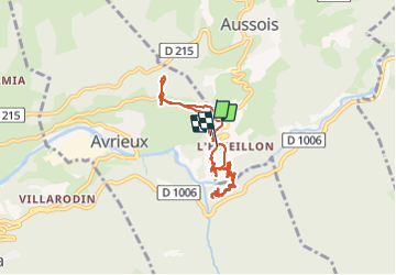

Length
7.5 km

Max alt
1362 m

Uphill gradient
494 m
Km-Effort
14.1 km

Min alt
1181 m

Downhill gradient
487 m
Boucle
Yes
Creation date :
2021-07-07 13:11:28.0
Updated on :
2021-07-17 13:38:54.296
2h16
Difficulty : Easy

FREE GPS app for hiking
 SityTrail
IGN / Geographical institutes
SityTrail Plus
The world is yours!
About
Trail Walking of 7.5 km to be discovered at Auvergne-Rhône-Alpes, Savoy, Avrieux. This trail is proposed by ajd26.
Photos


Positioning
Country:
France
Region :
Auvergne-Rhône-Alpes
Department/Province :
Savoy
Municipality :
Avrieux
Location:
Unknown
Start:(Dec)
Start:(UTM)
322185 ; 5009356 (32T) N.
Comments