


Refuge Thabor

ajd26
User
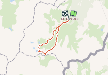

Length
12.2 km

Max alt
2510 m

Uphill gradient
610 m
Km-Effort
20 km

Min alt
1912 m

Downhill gradient
610 m
Boucle
Yes
Creation date :
2021-07-08 08:19:12.0
Updated on :
2021-07-17 13:43:20.661
4h40
Difficulty : Medium

FREE GPS app for hiking
 SityTrail
IGN / Geographical institutes
SityTrail Plus
The world is yours!
About
Trail Walking of 12.2 km to be discovered at Auvergne-Rhône-Alpes, Savoy, Modane. This trail is proposed by ajd26.
Description
départ du Lavoir au dessus de Valfréjus
Photos


Positioning
Country:
France
Region :
Auvergne-Rhône-Alpes
Department/Province :
Savoy
Municipality :
Modane
Location:
Unknown
Start:(Dec)
Start:(UTM)
314004 ; 5002164 (32T) N.
Comments