


Fond des fours et refuge

geoffrayLayeux
User
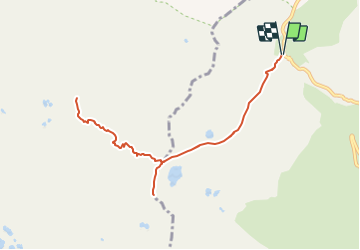

Length
9.9 km

Max alt
3046 m

Uphill gradient
939 m
Km-Effort
22 km

Min alt
2535 m

Downhill gradient
938 m
Boucle
Yes
Creation date :
2021-07-10 14:43:44.815
Updated on :
2021-07-10 14:44:18.158
5h06
Difficulty : Very difficult

FREE GPS app for hiking
 SityTrail
IGN / Geographical institutes
SityTrail Plus
The world is yours!
About
Trail Walking of 9.9 km to be discovered at Auvergne-Rhône-Alpes, Savoy, Bonneval-sur-Arc. This trail is proposed by geoffrayLayeux.
Positioning
Country:
France
Region :
Auvergne-Rhône-Alpes
Department/Province :
Savoy
Municipality :
Bonneval-sur-Arc
Location:
Unknown
Start:(Dec)
Start:(UTM)
345648 ; 5030006 (32T) N.
Comments