


Les sources supérieures de l'Arc

geoffrayLayeux
User
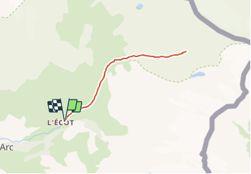

Length
12.3 km

Max alt
2753 m

Uphill gradient
734 m
Km-Effort
22 km

Min alt
2025 m

Downhill gradient
734 m
Boucle
Yes
Creation date :
2021-07-10 14:48:40.874
Updated on :
2021-07-10 14:49:15.529
5h01
Difficulty : Very difficult

FREE GPS app for hiking
 SityTrail
IGN / Geographical institutes
SityTrail Plus
The world is yours!
About
Trail Walking of 12.3 km to be discovered at Auvergne-Rhône-Alpes, Savoy, Bonneval-sur-Arc. This trail is proposed by geoffrayLayeux.
Positioning
Country:
France
Region :
Auvergne-Rhône-Alpes
Department/Province :
Savoy
Municipality :
Bonneval-sur-Arc
Location:
Unknown
Start:(Dec)
Start:(UTM)
350493 ; 5026993 (32T) N.
Comments