


Boucle-Pic-Ansabere: 02-08-2018

chasle
User
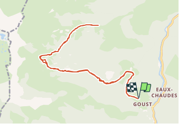

Length
13 km

Max alt
1737 m

Uphill gradient
955 m
Km-Effort
26 km

Min alt
854 m

Downhill gradient
949 m
Boucle
Yes
Creation date :
2021-07-12 07:19:17.298
Updated on :
2021-07-12 07:30:59.368

FREE GPS app for hiking
 SityTrail
IGN / Geographical institutes
SityTrail Plus
The world is yours!
About
Trail of 13 km to be discovered at New Aquitaine, Pyrénées-Atlantiques, Laruns. This trail is proposed by chasle.
Points of interest


Positioning
Country:
France
Region :
New Aquitaine
Department/Province :
Pyrénées-Atlantiques
Municipality :
Laruns
Location:
Unknown
Start:(Dec)
Start:(UTM)
708170 ; 4758601 (30T) N.
Comments