


orgere

verozerr
User
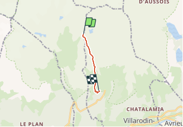

Length
3.9 km

Max alt
2505 m

Uphill gradient
45 m
Km-Effort
5.9 km

Min alt
2060 m

Downhill gradient
476 m
Boucle
No
Creation date :
2021-07-12 11:22:07.731
Updated on :
2021-07-13 06:35:55.773
1h52
Difficulty : Very easy

FREE GPS app for hiking
 SityTrail
IGN / Geographical institutes
SityTrail Plus
The world is yours!
About
Trail Walking of 3.9 km to be discovered at Auvergne-Rhône-Alpes, Savoy, Modane. This trail is proposed by verozerr.
Description
jusque lac de la partie
Positioning
Country:
France
Region :
Auvergne-Rhône-Alpes
Department/Province :
Savoy
Municipality :
Modane
Location:
Unknown
Start:(Dec)
Start:(UTM)
316277 ; 5014202 (32T) N.
Comments