


Valnontey

chgarit
User
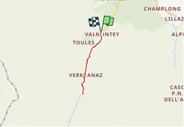

Length
8.1 km

Max alt
1801 m

Uphill gradient
145 m
Km-Effort
10 km

Min alt
1661 m

Downhill gradient
140 m
Boucle
Yes
Creation date :
2021-07-16 09:01:52.0
Updated on :
2021-07-16 12:35:42.447
2h06
Difficulty : Easy

FREE GPS app for hiking
 SityTrail
IGN / Geographical institutes
SityTrail Plus
The world is yours!
About
Trail Nordic walking of 8.1 km to be discovered at Aosta Valley, Unknown, Cogne. This trail is proposed by chgarit.
Photos

Positioning
Country:
Italy
Region :
Aosta Valley
Department/Province :
Unknown
Municipality :
Cogne
Location:
Unknown
Start:(Dec)
Start:(UTM)
370587 ; 5049551 (32T) N.
Comments